


Current Conditions
| Updated: @ 27-Apr-2024 6:30am | |||||||||||||||||||||||||||||||||||||||
| Summary / Temperature | Wind | Rain | Outlook | ||||||||||||||||||||||||||||||||||||
|
|
|
|
||||||||||||||||||||||||||||||||||||
| Humidity & Barometer | Almanac | Moon | |||||||||||||||||||||||||||||||||||||
|
|
|
|||||||||||||||||||||||||||||||||||||
| UV Index | Solar Radiation | ||||||||||||||||||||||||||||||||||||||
|
|
||||||||||||||||||||||||||||||||||||||


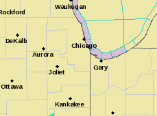
| NWS Weather Forecast - Outlook: Overnight & Saturday | ||||||
|
||||||

National Weather Service Forecast for Peotone!
|

|
|
|
||||||||||||||||||||||||||||||
|
|
|
||||||||||||||||||||||||||||||||||||||||||||||
Records and Average Hi/Low for Peotone
| Records and Average Hi/Low for this date in Peotone | Record Hi | Record Low | Record Rain | Record Gust | 18yr avg Hi/Low |
| ***Records and average Hi/Low temps from data collected at peotoneweather.com since April 2007 | 87°F 2021 |
30°F 2012 |
1.18in 2009 |
39mph 2021 |
62°F / 41°F |
Peotone's Yearly Records 2006-2024
| High Temperature | Low Temperature | High Wind Gust | High Heat Index | Low Wind Chill | |||||
| 2006 | 99°F 7/31/06 | 2006 | -05°F 02/18/06 | 2006 | 93mph 10/02/06 | 2006 | n/a | 2006 | n/a |
| 2007 | 95°F 6/14/07 | 2007 | -04°F 12/06/07 | 2007 | 60mph 10/21/07 | 2007 | n/a | 2007 | n/a |
| 2008 | 98°F 9/02/08 | 2008 | -09°F 1/25/08 | 2008 | 60mph 1/29/08 | 2008 | n/a | 2008 | n/a |
| 2009 | 96°F 6/24/09 | 2009 | -20°F 1/16/09 | 2009 | 49mph 3/08/09 | 2009 | 109°F 6/19/09 | 2009 | -41°F 1/16/09 |
| 2010 | 94°F 7/04/10 | 2010 | -05°F 1/10/10 | 2010 | 48mph 10/27/10 | 2010 | 116°F 7/23/10 | 2010 | -21°F 1/03/10 |
| 2011 | 101°F 7/21/11 | 2011 | -08°F 2/10/11 | 2011 | 48mph 11/13/11 | 2011 | 121°F 7/20/11 | 2011 | -25°F 1/10/11 |
| 2012 | 100°F 7/07/12 | 2012 | +03°F 1/20/12 | 2012 | 60mph 6/29/12 | 2012 | 118°F 7/06/12 | 2012 | -07°F 1/20/12 |
| 2013 | 96°F 7/18/13 | 2013 | -03°F 12/12/13 | 2013 | 60mph 6/12/13 | 2013 | 111°F 7/19/13 | 2013 | -21°F 12/12/13 |
| 2014 | 92°F 5/08/14 | 2014 | -14°F 01/06/14 | 2014 | 67mph 8/21/14 | 2014 | 113°F 8/25/14 | 2014 | -45°F 1/06/14 |
| 2015 | 92°F 7/17/15 | 2015 | -08°F 02/27/15 | 2015 | 60mph 11/12/15 | 2015 | 115°F 7/17/15 | 2015 | -30°F 1/08/15 |
| 2016 | 94°F 6/10/16 | 2016 | -11°F 12/19/16 | 2016 | 53mph 02/19/16 | 2016 | 116°F 7/24/16 | 2016 | -24°F 12/19/16 |
| 2017 | 96°F 6/12/17 | 2017 | -07°F 12/27/17 | 2017 | 59mph 02/28/17 | 2017 | 109°F 7/19/17 | 2017 | -21°F 12/27/17 |
| 2018 | 99°F 5/27/18 | 2018 | -14°F 01/02/18 | 2018 | 51mph 10/20/18 | 2018 | 116°F 6/30/18 | 2018 | -33°F 01/02/18 |
| 2019 | 97°F 7/20/19 | 2019 | -23°F 01/30/19 | 2019 | 58mph 02/24/19 | 2019 | 115°F 7/19/19 | 2019 | -58°F 01/30/19 |
| 2020 | 95°F 7/07/20 | 2020 | -08°F 02/14/20 | 2020 | 53mph 11/15/20 | 2020 | 112°F 7/26/20 | 2020 | -24°F 01/19/20 |
| 2021 | 96°F 8/24/21 | 2021 | -13°F 02/07/21 | 2021 | 55mph 12/16/21 | 2021 | 123°F 8/10/21 | 2021 | -30°F 02/07/21 |
| 2022 | 100°F 6/14/22 | 2022 | -11°F 01/26/22 | 2022 | 69mph 08/29/22 | 2022 | 119°F 7/05/22 | 2022 | -41°F 12/26/22 |
| 2023 | 97°F 8/24/23 | 2023 | 1.3°F 01/31/23 | 2023 | 66mph 03/31/23 | 2023 | 124°F 8/24/23 | 2023 | -20°F 2/03/23 |
| 2024 | 83°F 4/14/24 | 2024 | -10°F 1/14/24 | 2024 | 53mph 04/2/24 | 2024 | 83°F 4/16/24 | 2024 | -40°F 1/14/24 |
Season Countdown
|